Dark Sky Places in OR

List of darkest places in Oregon for stargazing, astrophotography, astrotourism, star parties, and astronomy club events. Often these are national and state parks and forests that are either remote or "protected" against light pollution.

National and state parks often let you stay overnight under the stars, hence their motto - "Half the park is after dark".

Bortle scale for sites is given where known. Also ask your local astronomy club for guidance as they will know the darkest places.
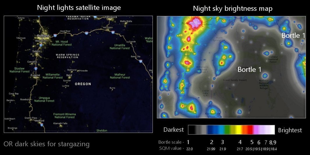
NAME BORTLE
Alvord Desert
Arizona Beach State Recreation Area 2
Bates State Park 1
Cape Blanco State Park 2
Cape Lookout State Park 2
Cape Sebastian 2
Carl G. Washburne State Park 2
Cascadia State Park 2
Catherine Creek State Park 2
Chandler State Wayside Park 1
Collier Memorial State Park 2
Cottonwood Canyon State Park 2
Crater Lake National Park
Deschutes National Forest
Emigrant Springs State Recreation Area 2
Fort Rock State Natural Area 1
Fremont-Winema National Forest
Golden & Silver Falls State Recreation Area 1
Goose Lake State Recreation Area 1
Hart Mountain
Hug Point State Recreation Area 2
Humbug Mountain State Park 2
Jackson F. Kimball State Recreation Area 2
John Day Fossil Beds
Joseph H. Stewart State Recreation Area 2
Klamath National Forest
Malheur National Forest
Malheur National Wildlife Reserve
Minam State Recreation Area 2
Mt. Hood National Forest
Ochoco National Forest 1
Oregon Outback
Prineville Reservoir State Park 2
Rogue River-Siskiyou National Forest
Saddle Mountain State Natural Area 2
Sitka Sedge State Natural Area 2
Siuslaw National Forest
Steens Mountain
Stonefield Beach State Recreation Area 2
Tillamook State Forest
Tokatee Klootchman State Natural Area 2
Umatilla National Forest
Umpqua National Forest 2
Unity Lake State Recreation Area 2
Wallowa Lake State Recreation Area 2
Wallowa-Whitman National Forest 1
White River Falls State Park 2
Willamette National Forest 2


Light Pollution Map w/ Bortle

On the left is a 2019 satellite image of OR showing light pollution from the NOAA National Geophysical Data Center. On the right is a 2015 light pollution map showing sky brightness at the zenith from World Atlas data. Colors correspond approximately to the Bortle scale. Use as a guide to find the darkest sky locations near you.

OR night sky light pollution map