Dark Sky Places in CA

List of darkest places in California for stargazing, astrophotography, astrotourism, star parties, and astronomy club events. Often these are national and state parks and forests that are either remote or "protected" against light pollution.

National and state parks often let you stay overnight under the stars, hence their motto - "Half the park is after dark".

Bortle scale for sites is given where known. Also ask your local astronomy club for guidance as they will know the darkest places.

NAME BORTLE
Admiral William Standley State Recreation Area 2
Ahjumawi Lava Springs State Park 2
Angeles National Forest
Anza-Borrego Desert State Park 2
Benbow State Recreation Area 2
Bodie State Park 1
Boggs Mountain Demonstration State Forest
Borrego Springs
Caspar Headlands State Natural Reserve 2
Castle Crags State Park 2
Channel Islands National Park
Cleveland National Forest
Death Valley National Park 1
Del Norte Coast Redwoods State Park 2
Eldorado National Forest
Ellen Pickett State Forest
Estero Bluffs State Park 2
Fort Ross State Park 2
Grizzly Creek Redwoods State Park 2
Grover Hot Springs State Park 2
Harry A. Merlo State Recreation Area 2
Hendy Woods State Park 2
Humboldt Lagoons State Park 2
Inyo National Forest
Jackson Demonstration State Forest
John Little State Natural Reserve 2
Joshua Tree National Park 2
Julia Pfeiffer Burns State Park 2
Julian
Kings Canyon National Park
Klamath National Forest
Kruse Rhododendron State Natural Reserve 2
Lake Tahoe Basin Management Area
Las Posadas State Forest
Lassen National Forest
Lassen Volcanic National Park 1
LaTour Demonstration State Forest
Limekiln State Park 2
Los Padres National Forest
Manchester State Park 2
McArthur-Burney Falls State Park 2
Mendocino National Forest 2
Modoc National Forest 1
Mono Lake Tufa State Natural Reserve 2
Mount Zion State Forest
Mountain Home Demonstration State Forest
Navarro River Redwoods State Park 2
Patrick's Point State Park 2
Pfeiffer Big Sur State Park 2
Pinnacles National Park
Plumas National Forest
Plumas-Eureka State Park 2
Point Reyes National Seashore
Point Sur State Park 2
Prairie Creek Redwoods State Park 2
Redwood National Park
Richardson Grove State Park 2
Salt Point State Park 2
San Bernardino National Forest
Sequoia National Park
Shasta-Trinity National Forest
Sierra National Forest
Sinkyone Wilderness 1
Six Rivers National Forest
Smithe Redwoods State Natural Reserve 1
Soquel Demonstration State Forest
Stanislaus National Forest
Tahoe National Forest
Van Damme State Park 2
Yosemite National Park 1


Light Pollution Map w/ Bortle

On the left is a 2019 satellite image of CA showing light pollution from the NOAA National Geophysical Data Center. On the right is a 2015 light pollution map showing sky brightness at the zenith from World Atlas data. Colors correspond approximately to the Bortle scale. Use as a guide to find the darkest sky locations near you.
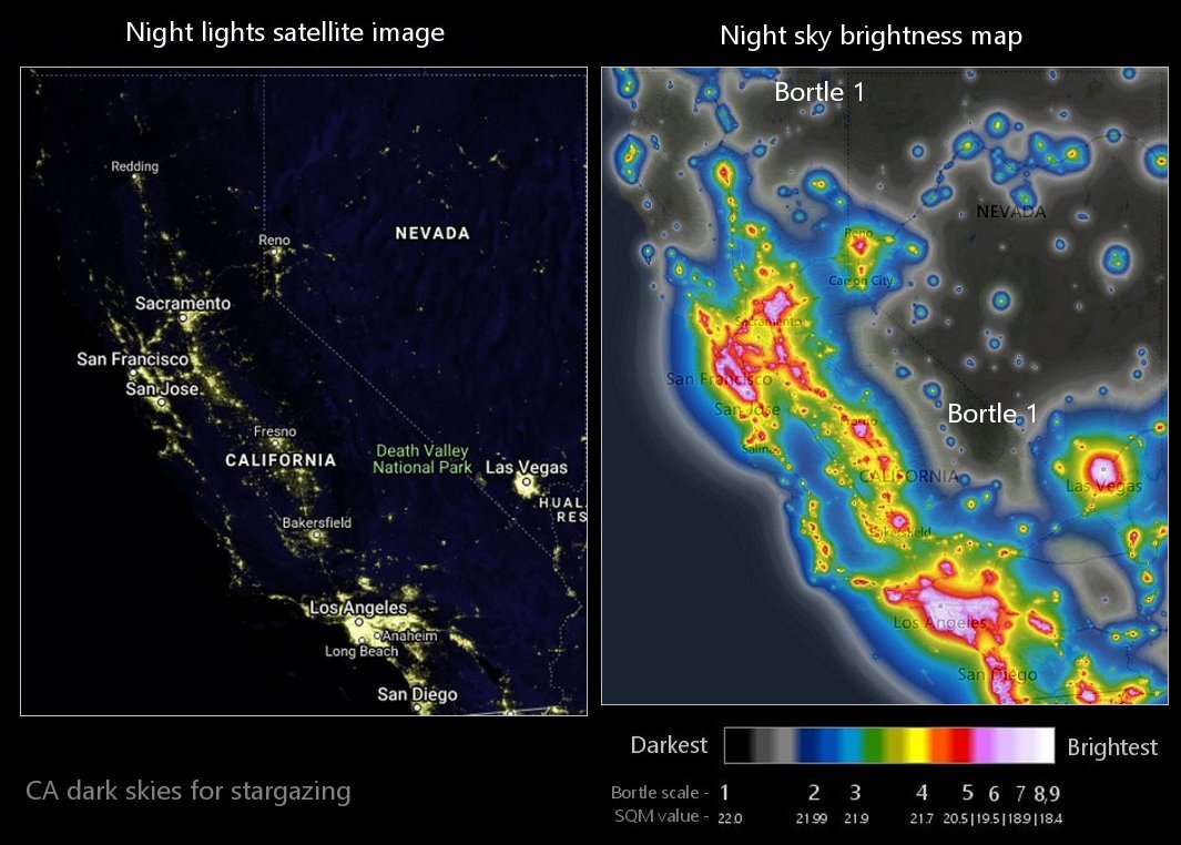
CA night sky light pollution map